Nuannaarpoq

August 1, 1997
Although the points in common between Arctic icefields and the Canyonlands of Utah are philosophical rather than specific, the Inuit word meaning "taking extravagant pleasure in being alive" seems a fitting title for this report on a hike to Druid Arch.
by Dick Gibson and Dave WilsonPhotos by Dave Wilson and Dick Gibson
We arrived in the Needles Area of Canyonlands National Park, and chose a nice east-facing campsite in the Squaw Flat Campground. The campground encircled a rock island so that no camper's view was soiled by the sight of other campers -- just the rock and sky. Upon exiting the car, the silence was overwhelming; you felt as though you had to whisper. The air was as still as a dragonfly on a limb, ready to spring into the afternoon heat.
We set off hiking about 12:00 noon. The day was hot, but at about 85ş, it was much cooler than the average for August in
Canyonlands. Enough scattered clouds promised at least occasional shade as well.
We headed southwest from the campground toward Big Spring Canyon. "Jeez, Dave, this seems a lot cooler than I thought it
would be." And we both had thought it would be wonderful. The slickrock and needles of Permian Cedar Mesa Sandstone were white and
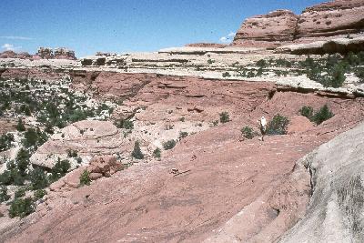 brown and red -- all possible shades of red. There must have been a thousand cairns, some just two rocks high, to define the trail
where it traversed bare rock.
brown and red -- all possible shades of red. There must have been a thousand cairns, some just two rocks high, to define the trail
where it traversed bare rock.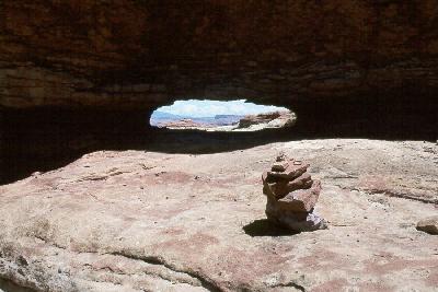 After walking perhaps a mile we noted that we had not seen another human being; we only had very
brief encounters with five people for the entire 16-mile, 7-hour hike. After walking perhaps a mile we noted that we had not seen another human being; we only had very
brief encounters with five people for the entire 16-mile, 7-hour hike.
The beauty was not one that takes your breath away, rather it soaked in slowly, bringing warmth and comfort, so that you could do nothing but gaze full circle and smile. The Grand Canyon is mystifying, but it is only one canyon; the Canyonlands are an endless Garden of Eden (but we didn't see any snakes).
The trail went up and around and over several relatively small divides between arroyos, reaching high vantage points that afforded
views to the east of the distant La Sal and Blue Mountains. Massive cross bedded sandstones everywhere suggested a vast desert
230 million years ago, not too different from today's climate, but in spite of our understanding of the geology, each new turn of the
trail gave a vision as of things newly created. We climbed up a set of switchbacks through brownish-pink sandstone to a white rim,
which we followed until it descended toward the next canyon west of Big Spring Canyon. Here we found a stagnant pool of water,
lush with tamarisk trees and other vegetation.
 We were expecting to join up with the Elephant Canyon trail, which comes south from Elephant Hill on the upper rim. First we
found a low arch, about three feet high and ten feet wide, supported on one side by a narrow, two-foot pillar, and soon the trail
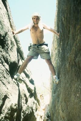
climbed and entered a narrow slot. This slot was wide enough to walk easily along the flat, sandy floor, but we played rock climber
and took plenty of pictures of ourselves chimneying between the walls. The slot ended in a side canyon of Elephant Canyon, and for some
time we followed this relatively wide arroyo - easy stream-bed walking with high eroded walls on either side. Our friends the
cairns were still present, and the "official" trail was often to one side of the valley floor. We tended to walk on the sandy bottom,
which was bare rock as often as not. Lots of evidence of big flash floods, and gathering gray clouds in the southeast, made us keep
a piece of an eye on the available high ground. We were expecting to join up with the Elephant Canyon trail, which comes south from Elephant Hill on the upper rim. First we
found a low arch, about three feet high and ten feet wide, supported on one side by a narrow, two-foot pillar, and soon the trail
climbed and entered a narrow slot. This slot was wide enough to walk easily along the flat, sandy floor, but we played rock climber
and took plenty of pictures of ourselves chimneying between the walls. The slot ended in a side canyon of Elephant Canyon, and for some
time we followed this relatively wide arroyo - easy stream-bed walking with high eroded walls on either side. Our friends the
cairns were still present, and the "official" trail was often to one side of the valley floor. We tended to walk on the sandy bottom,
which was bare rock as often as not. Lots of evidence of big flash floods, and gathering gray clouds in the southeast, made us keep
a piece of an eye on the available high ground.
The Debate: Six miles back to camp down a new trail, or five miles round trip to Druid Arch PLUS six miles back to camp. Plusses: Adrenaline, adventure, cool weather, beautiful scenery, things never before seen. Minuses: Low water. Winner: Plusses! "Wait, you realize we have come five miles, and we are about to go ELEVEN more on low water?" "Well, when you put it that way..."
As we continued up Elephant Canyon, it eventually got narrower and narrower, and the final 2 miles to Druid Arch was quite
enclosed, with several steep and slippery climbs. A few fairly large pools of water remained in the streambed in this segment, and a
couple places we had to switchback up obscure paths to get out of dry falls that were impossible to climb over. We finally were
within sight of Druid Arch, but the canyon is parallel to the flat dimension of the arch, so there was an extra half mile or so to hike
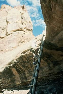
to the best view of it. This stretch had a lot of relatively steep terrain over angular boulders and rockfall, and there was a short metal
ladder and grab-bar mounted in the rock to help climb up one particularly smooth, steep stretch.
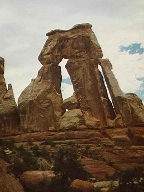 Finally and suddenly Druid Arch is revealed. Massive, light reddish-brown sandstone, with abundant purplish-black desert varnish,
the double arch rests on a base of more thinly-bedded alternating pink and white strata, all part of the Permian Cedar Mesa
sandstone. The right-hand, or western arch is a tall, narrow slot, with a thin outer upright like a flying buttress to the more
massive main arch, whose jagged lintel does suggest Stonehenge. The two thick columns are irregular, streaked with vertical
lines of desert varnish.
Finally and suddenly Druid Arch is revealed. Massive, light reddish-brown sandstone, with abundant purplish-black desert varnish,
the double arch rests on a base of more thinly-bedded alternating pink and white strata, all part of the Permian Cedar Mesa
sandstone. The right-hand, or western arch is a tall, narrow slot, with a thin outer upright like a flying buttress to the more
massive main arch, whose jagged lintel does suggest Stonehenge. The two thick columns are irregular, streaked with vertical
lines of desert varnish.
Druid Arch sits in a cul-de-sac at the furthest head of Elephant Canyon. Sheer walls rose to the high pinnacles of the Needles on all
sides. Resting beneath the towering arch, relaxing in the silence, no birds, no bugs, no sound. Thirst for a gallon of water gets satisfied with half an ounce of warm water, and dried fruit. DRIED?!? OK, only 8.5 miles back to camp. ONLY?!? Water was our only concern, but it didn't really bother us (yet). We would gladly trade some dehydration for the beauty and solitude we were experiencing.
Both of us are more inclined to take roads not taken than to return the same way, so after the necessary re-tracing of our steps
two miles back to the last junction, we headed east, and then southeast again, up one of the headwater tributary canyons of Elephant
Canyon. About this time we were down to less than an inch of water in our bottles -- and we still had nearly as far to go as we had
come.
 This canyon ultimately led to another apparently uncrossable head, but gentle switchbacks took us to a tall, 20-foot wooden ladder that narrowed up
to a fairly flat pouroff. An easy walk through a smooth gap in rusty cross-bedded sandstones brought us to a descending metal ladder, and with that we were in the
uppermost reaches of Squaw Canyon. The canyon floor was below us for a couple miles as we contoured around slick rock ledges.
We saw a deer in this area, the largest critter of the hike.
This canyon ultimately led to another apparently uncrossable head, but gentle switchbacks took us to a tall, 20-foot wooden ladder that narrowed up
to a fairly flat pouroff. An easy walk through a smooth gap in rusty cross-bedded sandstones brought us to a descending metal ladder, and with that we were in the
uppermost reaches of Squaw Canyon. The canyon floor was below us for a couple miles as we contoured around slick rock ledges.
We saw a deer in this area, the largest critter of the hike.
Fairly soon the trail seemed to disappear, but the cairns clearly let us into another slot. Unlike the one early in the hike, this one was
essentially closed to the sky. If the slot actually continued upward, it was a crack so narrow that even light could not get through.
The slot was more like a cave in a joint in the sandstone, with a ledge for walking above a narrower, deeper cleft into darkness
below. The entrance from our direction was actually pretty obvious, but where we exited it, it would have been hard to discern if
we had been approaching it from that direction.
Squaw Canyon is wide and quite vegetated in its lower reaches, with abundant trees and spots of mud and occasional pools. Out of
drinkable water for about 4 miles..... "Come on, Dick, just one more bend in the trail." We passed the turnoffs for Lost Canyon and
Peekaboo Spring, and finally reached the campground about 7:00 p.m. as the sun began to descend in the west.
 We drank A LOT of water.
Dinner that night was one of those meals that are memorable beyond any possibility of telling others. Refried beans out of the can
and salsa on chips and in sheepherder bread sandwiches, with pineapple chunks for desert, doesn't sound great, maybe it doesn't
even sound very good. But it was.
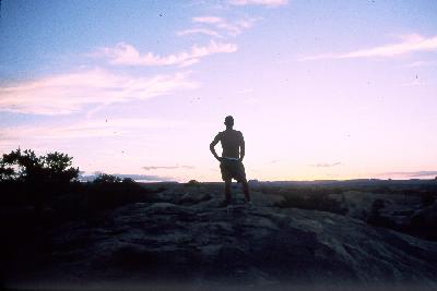
Then the stars came out.
"On the beautiful trail I am, with it
I wander." -- Navajo Dawn Boy's Song
Back to Expeditions Page
|