
INTEGRATED REGIONAL TECTONIC INTERPRETATION OF PARTS OF SOUTHEAST ASIA
 Bird Geophysical and Gibson Consulting have teamed up to offer this play-oriented tectonic interpretation on a proprietary, non-exclusive basis.
Phase 2, covering most of central Indonesia, is complete and the package is available for immediate delivery. Please visit Bird Geophysical's web site for additonal displays of the data for both Phase 1 (South China Sea) and Phase 2 (Java Sea area).
 |
 The work is based on high-quality satellite-derived gravity data and magnetic data
available from the Committee for Co-ordination of Joint Prospecting for Mineral Resources in
Asian Offshore Areas (CCOP), and includes definition of oceanic fracture zones and their
interaction with prospective continental margin areas; the continent-oceanic crustal boundary;
regional detail in rifts and back-arc basins, including depocenters with major structures and
accommodation zones; distribution of volcanics and depth to basement where possible; and a
regional plate-tectonic framework for planning hydrocarbon exploration.
The work is based on high-quality satellite-derived gravity data and magnetic data
available from the Committee for Co-ordination of Joint Prospecting for Mineral Resources in
Asian Offshore Areas (CCOP), and includes definition of oceanic fracture zones and their
interaction with prospective continental margin areas; the continent-oceanic crustal boundary;
regional detail in rifts and back-arc basins, including depocenters with major structures and
accommodation zones; distribution of volcanics and depth to basement where possible; and a
regional plate-tectonic framework for planning hydrocarbon exploration.
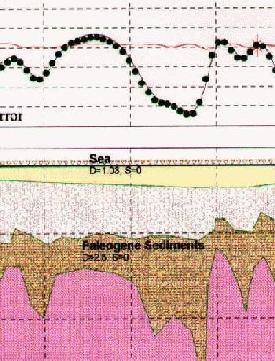
In addition to map interpretations, interpreted megaregional cross-sections based on gravity and magnetic models are included in the study.
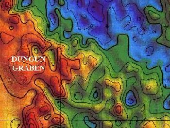 Satellite-derived gravity data are only available in offshore areas, but the information content of these data is significant. Local transtensional pull-apart grabens, such as the Dungun Graben in the Malay Basin, are clearly expressed. The structure at Bongkot Field (Gulf of Thailand) is also evident, as are the likely basement platforms that form the substrate for carbonate buildups in the Luconia Province, offshore Sarawak, and in the vicinity of the Lihua Field in the Pearl River Mouth area. Satellite-derived gravity data are only available in offshore areas, but the information content of these data is significant. Local transtensional pull-apart grabens, such as the Dungun Graben in the Malay Basin, are clearly expressed. The structure at Bongkot Field (Gulf of Thailand) is also evident, as are the likely basement platforms that form the substrate for carbonate buildups in the Luconia Province, offshore Sarawak, and in the vicinity of the Lihua Field in the Pearl River Mouth area.  Our interpretation shows much structural detail throughout the area studied, which is approximately equivalent in area to the entire Gulf of Mexico or the entire North Sea. We have used computer models along selected regional cross-sections to validate the qualitative map interpretation and to suggest involvement of basement, Paleogene, and/or Neogene strata in the inferred structures. Our interpretation shows much structural detail throughout the area studied, which is approximately equivalent in area to the entire Gulf of Mexico or the entire North Sea. We have used computer models along selected regional cross-sections to validate the qualitative map interpretation and to suggest involvement of basement, Paleogene, and/or Neogene strata in the inferred structures.
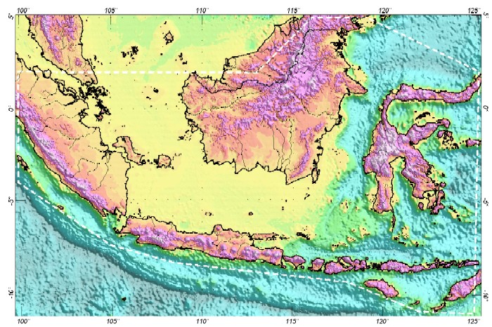
SOUTH CHINA SEA
The first phase of a multi-project program covers the South China Sea (including
the Spratly and Paracel Islands), the Gulf of Tonkin and coastal
Viet Nam, the Gulf of Thailand and the Malay Basin, the northern
Natuna Sea, and the north coast of Borneo and the Palawan Island
area. This project is completed and has been delivered to the
original subscribers. The cost per company is US $30,000.
INDONESIA
This phase includes most of the marginal seas of Indonesia west of Irian Jaya.
This project is completed and has been delivered to the original
subscribers. The cost per company is US $30,000.
for more information, contact
Dale Bird, Bird Geophysical, 16903 Clan Macintosh, Houston, TX 77084
(281) 463-3816 or FAX (281) 463-7899
dale@birdgeo.com
or Dick Gibson, Gibson Consulting, 301 N. Crystal St., Butte, Montana 59701 USA; ph/fax (406) 723-9639
In Europe, please contact our representative Alan B Reid PhD, Reid Geophysics
49 Carr Bridge Drive,
Leeds LS16 7LB UK
Phone: +(44)-113-261-0252 • Fax: +(44)-113-293-0062 • e-mail
|