Travels With Cody
Text and photos by Dick Gibson
Thanksgiving 2000
Canine comments by Cody (R.I.P.; 1998-2011)

Rimes of the Madison
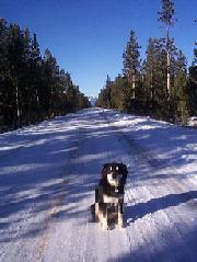 The crescent moon, two days short of the new, was bright with earthshine in the pre-dawn silence of a crisp Thanksgiving morning. From a low of minus 15° the temperature had climbed with the sun into the single digits when Cody and I set out into Yellowstone Park along the closed and snow-covered West Entrance Road. A raven, black against blue in the sunrise stillness, was the only moving thing. He flew above us along the straight length of the road, surveying our walk. A few cross-country skiiers were our only other company — we mostly had the road and the Park to ourselves. The road was snowy but nearly bare in a few places near the entrance, but further in it was completely covered but well-packed by Park maintenance vehicles. The crescent moon, two days short of the new, was bright with earthshine in the pre-dawn silence of a crisp Thanksgiving morning. From a low of minus 15° the temperature had climbed with the sun into the single digits when Cody and I set out into Yellowstone Park along the closed and snow-covered West Entrance Road. A raven, black against blue in the sunrise stillness, was the only moving thing. He flew above us along the straight length of the road, surveying our walk. A few cross-country skiiers were our only other company — we mostly had the road and the Park to ourselves. The road was snowy but nearly bare in a few places near the entrance, but further in it was completely covered but well-packed by Park maintenance vehicles.
We drove down to West Yellowstone with Clyde and Liz Cody from Boise, who had come up to the Field Station for a pre-Thanksgiving visit. We joined their traditional Thanksgiving trek to West Yellowstone where they have gone cross-country skiing for several years. On Thanksgiving day, Cody and I walked up the road while Clyde and Liz attacked the cross-country ski trails south of town.
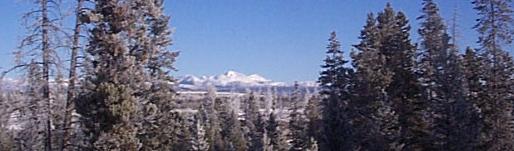
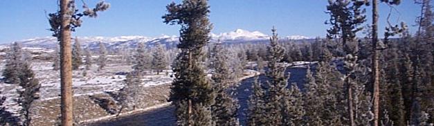
About a mile east of the entrance station, the road curves close to the Madison River, and several side roads lead to snow-blanketed and empty parking lots looking along the river. Beyond are vistas of Mt. Holmes and the peaks of the northwest corner of the Park, which rise above 10,000 feet. West Yellowstone and the mostly level entrance road lie at about 6900 feet. Mt. Holmes itself is a Tertiary intrusive, but beyond it are Paleozoic outcrops, including Mississippian carbonates that have been dissolved in the subsurface to produce the calcareous terraces at Mammoth Hot Springs, which is just beyond the hills. These peaks are the southern limit of the Gallatin Range.
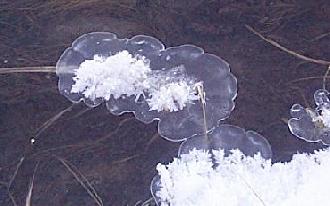 The river flowed swiftly, and was icy only along snags and logs near its banks. There, every grass and reed that raised its stalk above the waterline slowed the water enough to let an ice-shelf form. The river flowed swiftly, and was icy only along snags and logs near its banks. There, every grass and reed that raised its stalk above the waterline slowed the water enough to let an ice-shelf form. 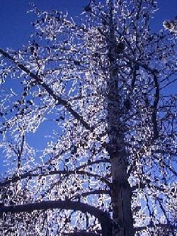 But the river put a great breath of moisture into the air which condensed on trees, grass, and weeds. Everything was coated, even the biggest trees. More exposed branches were more densely encrusted, but even pine needles had caught the rime. As befits a bigger stream, the hoarfrost was far more extensive than its counterpart along the South Boulder. And quite possibly the Madison's water is warmer — we were less than 10 miles downstream from Madison Junction, where the Firehole and Gibbon Rivers come together to form the Madison. Both of those upper tributaries drain major thermal areas of the park. But the river put a great breath of moisture into the air which condensed on trees, grass, and weeds. Everything was coated, even the biggest trees. More exposed branches were more densely encrusted, but even pine needles had caught the rime. As befits a bigger stream, the hoarfrost was far more extensive than its counterpart along the South Boulder. And quite possibly the Madison's water is warmer — we were less than 10 miles downstream from Madison Junction, where the Firehole and Gibbon Rivers come together to form the Madison. Both of those upper tributaries drain major thermal areas of the park.
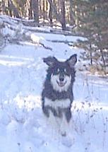 After our 4-block walk through town to the Park entrance, I had unleashed Cody to romp freely, though I kept him on a fairly close verbal rein. It turned out that this was illegal — when we were almost back to the gate, a ranger out jogging told me to leash him, for his own good: a wolf pack had been spotted within a mile of the entrance just the week before. Neither the first nor last time I've violated federal law, but we walked the last half-mile with Cody straining and lunging at the rope, with me wishing I was on a sled that he could pull! But for most of the hike he happily explored the woods within a few hundred feet of the road. When we encountered skiiers, he contained his enthousiastic desire to greet them (at my command of "go slow," which is our equivalent of "heel") and walked with me. After our 4-block walk through town to the Park entrance, I had unleashed Cody to romp freely, though I kept him on a fairly close verbal rein. It turned out that this was illegal — when we were almost back to the gate, a ranger out jogging told me to leash him, for his own good: a wolf pack had been spotted within a mile of the entrance just the week before. Neither the first nor last time I've violated federal law, but we walked the last half-mile with Cody straining and lunging at the rope, with me wishing I was on a sled that he could pull! But for most of the hike he happily explored the woods within a few hundred feet of the road. When we encountered skiiers, he contained his enthousiastic desire to greet them (at my command of "go slow," which is our equivalent of "heel") and walked with me.
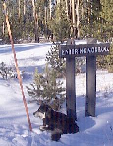
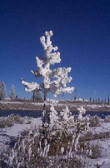 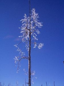 The state line is about 3 miles in from the Park boundary, and we went nearly two miles beyond that. Most interesing were the side roads to spots that in summer would be congested scenic vistas. For us, they were private entrances to the delicate ice flowers along the riverbanks. Many of the trees were so heavily coated with frost, they looked like flocked Christmas trees, sharply contrasting with the cobalt-blue sky in the background. Among the most fascinating were tall bare trees that were coated with rime right up to the tops. The state line is about 3 miles in from the Park boundary, and we went nearly two miles beyond that. Most interesing were the side roads to spots that in summer would be congested scenic vistas. For us, they were private entrances to the delicate ice flowers along the riverbanks. Many of the trees were so heavily coated with frost, they looked like flocked Christmas trees, sharply contrasting with the cobalt-blue sky in the background. Among the most fascinating were tall bare trees that were coated with rime right up to the tops.
At almost five miles in, we encountered one of the westernmost areas of burned trees from the fires of 1988. This happens to be one of the areas that was truly burned, killing most of the trees within the fire area. The Park Service has built a 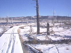 boardwalk trail through the margin of the burn zone so that one can compare it to a healthy forest. The boundary between the two is quite sharp. One cross-country skiier had skated down the boardwalk before us — and I must admit that Cody did not stay on the wooden path, yet another violation of Federal law. boardwalk trail through the margin of the burn zone so that one can compare it to a healthy forest. The boundary between the two is quite sharp. One cross-country skiier had skated down the boardwalk before us — and I must admit that Cody did not stay on the wooden path, yet another violation of Federal law.
We saw few rocks on the trek other than boulders along the banks of the river. The Madison here is entering a relatively low, flat area that is probably a basin-range graben related to the same extension and faulting that broke in 1959 to cause the Madison Slide. The substrate below Quaternary sediments is almost certainly Plateau Rhyolite, which crops out in the hills south of the river (and mostly invisible from our traverse). Here, we were beyond the edge of the caldera, but that edge lies near Madison Junction, only about five miles further up the road from where Cody and I turned back.
 As always, the return trip seemed a lot faster than the outbound expedition. The walk totaled about 9˝ miles and took us about 5 hours. The temperature was about 18° when we got back to town — to a West Yellowstone that seemed a ghost town compared to the congestion of summer. Within a few weeks, snowmobile season would begin and the streets would be full again — though, perhaps, not for too many more years, given the planned phase-out of snowmobiles in the Park. It was nice for us to have a quiet time both in the park and in town. Cody slept in the car, since the motel had a strict no-pets policy, but he seemed to tolerate that quite well. I think he sees the car as a "secure" area, an extension of the territory of his "pack" — meaning me. As always, the return trip seemed a lot faster than the outbound expedition. The walk totaled about 9˝ miles and took us about 5 hours. The temperature was about 18° when we got back to town — to a West Yellowstone that seemed a ghost town compared to the congestion of summer. Within a few weeks, snowmobile season would begin and the streets would be full again — though, perhaps, not for too many more years, given the planned phase-out of snowmobiles in the Park. It was nice for us to have a quiet time both in the park and in town. Cody slept in the car, since the motel had a strict no-pets policy, but he seemed to tolerate that quite well. I think he sees the car as a "secure" area, an extension of the territory of his "pack" — meaning me.
The day was capped by a Thanksgiving dinner in a motel room with Clyde and Liz and friends of theirs from Idaho, Oregon, and Colorado. The next day Cody and I had a leisurely return drive to the Station, catching a view of three moose along the road south of Ennis. A new inch of snow, the first in more than a week, had dusted the northern Tobacco Roots, but the sun was bright and welcoming.

©2001 Richard I. Gibson
Back to Expeditions Page
|