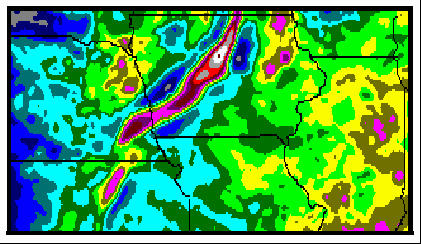
 This study is a detailed, play-oriented interpretation of published gravity and magnetic data from the conterminous United States. It is intended as a guide to play and prospect generation in both frontier and mature hydrocarbon exploration provinces. For example, analysis of the Mid-Continent Gravity Anomaly (above) can suggest where basement structures of the Precambrian rift system have affected overlying strata. In Kansas, there appears to be a clear relationship between inferred rift-related basement faulting and long, narrow oil fields.
Products of the study include detailed interpretations in
24 areas. The scope and details of each area vary due to the
information content of the data. For example, interpretation
and play maps of the Black Warrior Basin are at a scale of 1:2,500,000,
while the maps of Nevada and Montana are at 1:500,000. In areas
that are mapped at relatively large scale, recommendations are
nearly at the prospect level.
Thirty separate interpretation and play maps accompany the report, which consists of a 160-page text including 52 figures. Some of the plays and interpretations are given as text figures if appropriate. More than 150 specific locations are recommended for various levels of further exploration.
This project represents six months of intense work, drawing on years of interpretation experience. The work was done by Richard I. Gibson when he was Director of Gravity and Magnetics for Everest Geotech, Inc. Gibson Consulting has all rights to this study. The work was supported initially by three clients.
Price
The complete package, including reproducible copies of the interpretation maps
and a set of the published maps on which the intepretations were
based, is available. Cost is $10,000. Basin-scale subsets, updated with a look at any newer published data, are also available.
|
Table of Contents
Introduction
Major Basement Tectonic Features of the US
Northern Mid-Continent & East Coast
Michigan Basin | Illinois Basin | Mid-Continent Rift
Western Appalachian Basin | Eastern Triassic Basins
Gulf of Mexico & Vicinity
Black Warrior Basin | Reelfoot Rift | Smackover Trend | Gulf
Coast (TX-LA)
Florida, Florida Shelf, Bahamas Platform
Central Plains
Permian Basin | Denver and Raton Basins | Oklahoma-Kansas Area
Colorado Plateau
Baca Basin | San Juan Basin | Utah Hingeline & NW Colorado Plateau
Paradox Basin | Rio Grande Rift | Pedregosa Basin
Rocky Mountain Thrust & Foreland
Western Montana | Central Montana | Williston Basin | Uinta-Piceance
Creek Basins
Wyoming Foreland & Thrust Belt
West Coast
California | Columbia Plateau Area
Basin and Range (Nevada-Utah>
Summary of Recommendations
List of Maps
(excluding maps that appear as text figures)
Major Features of US (1:5 million & 1:2.5 million)
Michigan Basin Interpretation
Michigan Basin Plays
Illinois Basin Area, Interpreted basement lithology
Illinois Basin Area, Interpretation & Plays
Mid-Continent Rift, basement lithologic interpretation
Mid-Continent Rift, fault interpretation
Western Appalachians, Basement lithologies
Western Appalachians, Interpretation
Reelfoot-Black Warrior-Smackover: Basement Lithologies
Reelfoot-Black Warrior-Smackover: Faults & Lineaments
Black Warrior-Reelfoot: Plays
Florida: basement lithologies
Florida: Interpretation
Gulf Coast: Interpretation & Plays
Permian Basin: Interpretation & Plays
Denver-Raton: Interpretation & Plays
Colorado Plateau: basement lithologies
Colorado Plateau: Interpretation & Plays
Western Montana Interpretation
Eastern Montana Interpretation and Plays
Williston Basin (ND) Interpretation and Plays
Wyoming basement lithologies
Wyoming Interpretation and Plays
Uinta-Piceance Creek Interpretation & Plays
California: Lithologies and Tectonics
Washington-Oregon Interpretation
Nevada basin-range: Interpretation & Plays
Utah basin-range: Interpretation and Plays
|