by
Richard I. Gibson
Gibson Consulting
Presented at the International AAPG meeting, Denver, June 1994
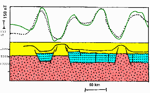
Detailed geometry of grabens and horsts in the West Siberian Rift System is inferred from magnetic data. Because most of the grabens in the central and northern part of the West Siberian Basin are filled with basalt, grabens are expressed as magnetic highs while horsts, lacking basalt, are magnetic lows. Many productive structures, including Urengoy, Yamburg, and Zapolyarnoye Gas Fields, show excellent correlation with magnetic lows. Using this expression as a starting point, specific faults are interpreted that display geometries typical of rift settings worldwide. Details of the structural style, including rift splays, gaps, offsets, and passes are identified. Such structural mapping should help guide exploration in the southern, underexplored part of the West Siberian Basin. Magnetic data there are more equivocal in terms of interpretation of grabens and horsts, but they do serve as a useful guide. Using this expression as a starting point, specific faults are interpreted that display geometries typical of rift settings worldwide. Details of the structural style, including rift splays, gaps, offsets, and passes are identified. Such structural mapping should help guide exploration in the southern, underexplored part of the West Siberian Basin. Magnetic data there are more equivocal in terms of interpretation of grabens and horsts, but they do serve as a useful guide.
Transfer zones (accommodation zones) are also interpreted from the magnetic data, where they are clearly expressed as long linear disruptions of anomalies; in some locations, they are marked by anomalies elongate along the transfer zones. This may indicate the presence of small-scale structural development or fracturing. In the West Siberian Basin, fracture zones appear to delimit areas of production rather than enhancing it, although there are some exceptions. In many other rifts, intersections of uplifts and accommodation zones mark structurally high positions that are preferred zones of accumulation of hydrocarbons.
You may also be interested in our Custom Bibliography covering more than 300 papers in English on the West Siberian Basin, as well as a short report on Urengoy Field
Back to Abstracts Index
Back to Custom Bibliography page
Back to Former Soviet Union Index
Back to Rapid Research Projects
|