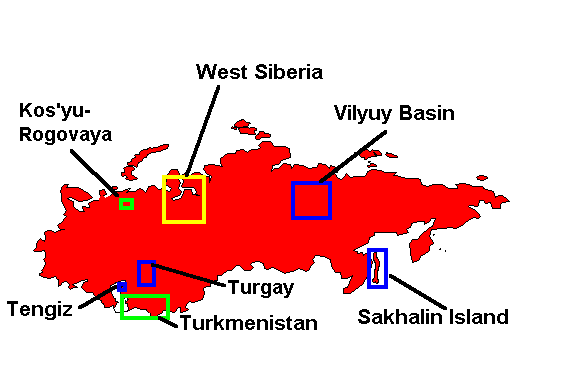
The map below is an index to specific project areas. For more information, click on a name or rectangle on the map, or if your browser does not support client-side image maps, click on a name in the list below the map. The remainder of this document (following the map and special projects list) describes our comprehensive package that covers the entire Former Soviet Union.
Special Projects List
Analysis of the entire Former Soviet Union
 The centerpiece of this comprehensive package of products is a detailed, qualitative tectonic and geologic interpretation of published magnetic data covering the entire former Soviet Union. The display scale is 1:2,500,000, and the interpretation is in 18 25"x35" sheets. The magnetic data were integrated with surface geology, hydrocarbon production data, and other information when possible. The year-long study was delivered to the original participating companies (BHP, JNOC, Unocal, Marathon, and Conoco) in December 1990. Subsequently the package was purchased by three other companies (Petro-Canada, Shell, and AGIP). The centerpiece of this comprehensive package of products is a detailed, qualitative tectonic and geologic interpretation of published magnetic data covering the entire former Soviet Union. The display scale is 1:2,500,000, and the interpretation is in 18 25"x35" sheets. The magnetic data were integrated with surface geology, hydrocarbon production data, and other information when possible. The year-long study was delivered to the original participating companies (BHP, JNOC, Unocal, Marathon, and Conoco) in December 1990. Subsequently the package was purchased by three other companies (Petro-Canada, Shell, and AGIP).
Magnetic data provide a wealth of information about basins in addition to the classical use of determining basement depth. Subtle features in such data often point toward unexpected relationships between the basement and even much shallower exploration targets. In other locations, intelligent lithologic inferences can help define structure in considerable detail.
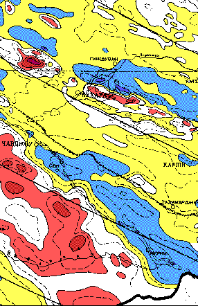 |
Magnetic Map of Bukhara Area, Uzbekistan
and Turkmenistan. Data from published
magnetic map of the Soviet Union
(Kolosova, 1974); north at top, contour
interval mostly 100 gamma (nT). The shallow
NW-SE trending Bukhara Step is evident in
the high frequency magnetics in the upper
part of the image. |
Magnetic data are, of course, best used in a synergistic manner, integrating them with gravity, seismic, on surface and subsurface geologic information. The first comprehensive geophysical data set for the USSR available in the West was the magnetic maps published in 1977. Those maps form the principal data set for this interpretation. While the entire country was examined, emphasis was placed on the basins and basin complexes of special interest to hydrocarbon explorationists.
The data set is generally of high quality for the display scale. Gibson Consulting hired EDCON, Inc., to digitize the contours of the published magnetic maps, in order to create a digital product and to permit better display of the maps. Gibson Consulting owns these data. Although some deliberate skewing may be present in the original published data, this project did not identify areas where there seemed to be a significant problem. In fact, in many areas, we are essentially certain that no skewing is present. Elsewhere, the possibility of up to 25 km (1 cm at this scale) of offset may exist.
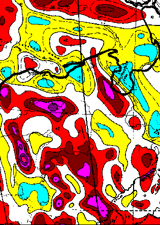 |
The Timan-Pechora area was a Baikalian (about
600 Ma) addition to the northeast corner of the East
European Craton. The suture is evident in magnetic
data (SW of the area of this image). This map shows
magnetic expression of basement features that
predisposed late Paleozoic reefs to grow.
Data from Kolosova, 1974. |
The initial analysis was qualitative because of the perceived need for a Western-style tectonic framework for the former Soviet Union. Also, at the given scale, models can be made to support several highly diverse interpretations, and it is our view that unconstrained magnetic models are less informative than no model at all. Since the main study was completed, we have done local analyses that do include quantification in the form of modeling. You may also be interested in the Abstracts of several papers related to the magnetic interpretation.
Cost
The complete Basement Tectonic Interpretation package represents more than 20 person-months of professional work, and is available for immediate delivery. The price for the complete package is US$50,000. Many of the components of the package are available separately. The complete list of products is given below.
Product list
The magnetic interpretation report is provided in an oversized atlas format (25x35", or 60x90 cm) in a heavy-duty post binder. The report includes the following items, with magnetic data and interpretations for each of the 18 sheets at 1:2,500,000 scale:
 Color photographic reproductions of versatec plots of data digitized from the magnetic maps Color photographic reproductions of versatec plots of data digitized from the magnetic maps
Clear film overlays of the interpretation
93-page text, including 24 generalized stratigraphic columns
All other items are part of the Comprehensive Package, but are also available separately.
|